A good Bible maps and charts book can make journeys, kingdoms, timelines, and unfamiliar places easier to follow. But these references vary: some emphasize historical geography, while others pair maps with book summaries, charts, or study aids.
These 10 picks cover compact quick references, visual atlases, and broader study companions. Use the guide below to match the format to how you actually read or teach.
Best 10 Bible Maps and Charts Book Picks for 2026
Best All-Around Reference
Rose Book of Bible Charts, Maps and Time Lines

- 200+ reproducible visuals
- Then and Now Bible maps
- Two 24-inch foldouts
Best For: Broad, visual Bible study and teaching
Best Map Overlays
Deluxe Then and Now Bible Maps

- Eight clear map overlays
- Spiral-bound, lay-flat pages
- Story maps, charts, and timelines
Best For: Comparing ancient and modern geography
Best for Printable Charts
Rose Book of Bible Charts, Volume 2

- 30+ Bible topics
- Reproducible charts and worksheets
- Covers history and discipleship
Best For: Printable lesson and study materials
Best Bible-Cover Companion

- 17 full-color maps
- Fits most Bible covers
- Modern locations marked in red
Best For: Portable then-and-now map lookup
Most Comprehensive Visual Reference
Rose Handbook of Bible Charts, Maps, and Timelines

- Over 250 full-color charts and maps
- More than 500 illustrated pages
- Covers Bible topics and Christian history
Best For: Broad visual study and lesson planning
Best Book-by-Book Overview
Nelson's Complete Book of Bible Maps and Charts
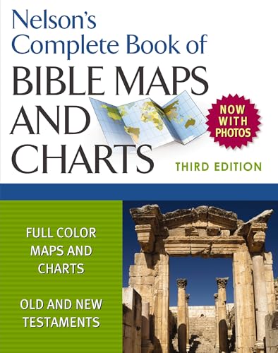
- Introductions to each Bible book
- Full-color maps and charts
- Historical articles and diagrams
Best For: Teaching or studying the Bible book by book
Best Lay-Flat Study Companion

- Spiral binding lies flat
- Foldout timeline and 200-plus-entry dictionary
- Maps, photos, and reading plan
Best For: Hands-on personal or group study
Best for Teaching
Rose Book of Bible Charts, Maps & Time Lines Vol. 1

- 230 full-color pages
- More than 200 reusable visuals
- Spiral-bound teaching format
Best For: Group leaders and visual teaching
Best for Bible Geography

- More than 300 visual resources
- Covers major biblical journeys and places
- Compact 4.8-by-7-inch size
Best For: Readers seeking biblical geography
Best for the Big Picture

- Walk-through of all 66 books
- Summaries, maps, charts, and timelines
- Compact portable format
Best For: New readers seeking a Bible overview
Best All-Around Reference – Rose Book of Bible Charts, Maps and Time Lines
If you want one bible maps and charts book covering a wide range of study topics, this updated 10th Anniversary Edition is a strong starting point. Its 230 pages include more than 200 reproducible charts, maps, and timelines, plus foldouts for a Bible timeline and Jesus’ genealogy.
Best For: Readers and teachers who want a broad, visual Bible reference in one volume.
Pros:
- Covers Bible books, people, teachings, history, and prophecy alongside maps and timelines.
- Includes Then and Now maps connecting biblical locations with modern geography.
- Full-color, reproducible charts are useful for lessons and study handouts.
Cons:
- Its broad scope may be more than you need if you only want maps.
- A 230-page volume is less compact than a fold-out map pamphlet.
Choose this for variety rather than a map-only focus: the foldouts and wide topic coverage make it useful when your study moves between geography, chronology, and biblical themes.
Best Map Overlays – Deluxe Then and Now Bible Maps
For a bible maps and charts book centered on place, this expanded edition makes ancient-to-modern comparisons especially tangible. Eight clear plastic overlays place present-day cities and countries over relief Bible maps, while the spiral binding keeps the book open as you study.
Best For: Visual learners and teachers comparing biblical geography with current locations.
Pros:
- Eight overlays make then-and-now comparisons direct.
- Spiral binding lies flat, and the type is larger than in many Bible atlases.
- Includes maps for Bible stories along with selected charts and timelines.
Cons:
- At 66 pages, it is a more focused resource than a large chart collection.
- Geography is the main attraction, so it may not suit someone seeking extensive charts across many topics.
Pick this edition if seeing modern geography on top of biblical maps is your priority; its overlays offer a different study experience from maps printed side by side.
Best for Printable Charts – Rose Book of Bible Charts, Volume 2
If your search for a bible maps and charts book is really about ready-to-use charts, Volume 2 deserves a look. This 236-page collection presents full-color, reproducible charts and worksheets on more than 30 topics, from Bible translations and Old Testament figures to discipleship.
Best For: Teachers and group leaders who want printable topic overviews and worksheets.
Pros:
- Reproducible charts and worksheets support lessons, homeschool use, and personal study.
- Topics span Bible history, both Testaments, and Christian discipleship.
- Includes comparisons involving Christianity and other religions or belief systems.
Cons:
- The supplied description emphasizes charts and worksheets, not map coverage.
- Its many topics may be unnecessary if you need only a compact geography reference.
This is the teaching-oriented choice when printable explanations matter more than tracing locations. For then-and-now geography, a dedicated map title is a better match.
Best Bible-Cover Companion – Then & Now Bible Maps
When a full-size bible maps and charts book is more than you want to carry, this slimline pamphlet keeps geographic context close at hand. Its 14 panels unfold to 38 inches and contain 17 full-color maps marking modern cities and boundaries in red.
Best For: Readers who want a portable map reference that fits in most Bible covers.
Pros:
- Fits inside most Bible covers when folded.
- Shows biblical places alongside modern-day names and boundaries.
- Covers areas and journeys including the Holy Land, ancient empires, and Paul’s travels.
Cons:
- The pamphlet format does not provide the broad chart collections found in larger books.
- Its 14 panels offer less room for extended explanations than a full-length reference.
Choose it as a convenient supplement to Scripture, especially when your recurring question is where a biblical place sits on today’s map.
Most Comprehensive Visual Reference – Rose Handbook of Bible Charts, Maps, and Timelines
If you want a bible maps and charts book with plenty of material to browse, the Rose Handbook offers more than 500 full-color pages covering biblical places, people, teachings, and Christian history.
Best For: Readers and group leaders who want a broad, visual reference for study or lesson planning.
Pros:
- Includes over 250 full-color charts and maps, plus illustrations and diagrams.
- Covers timelines, genealogies, Jewish feasts, the Gospels, and Christian living topics.
- Clear headings and side-by-side comparisons make topics easier to scan.
Cons:
- Its broad scope may be more than you need if you only want biblical geography.
- Readers seeking a compact reference may prefer a shorter book.
Choose this one when variety matters: it works as a quick lookup tool and a source of visual material for deeper study.
Best Book-by-Book Overview – Nelson's Complete Book of Bible Maps and Charts
Nelson’s Complete Book is a bible maps and charts book for readers who want to follow the Old and New Testaments with visual aids and introductions to each biblical book. This third edition runs 480 pages.
Best For: Small-group leaders, Bible teachers, and readers who want a visual overview of the whole Bible.
Pros:
- Includes full-color, high-resolution maps and charts.
- Introductions to each Bible book support book-by-book study.
- Historical articles and diagrams add context and organize information.
Cons:
- Its 480-page length is less convenient if you want a brief reference.
- The supplied description does not mention a foldout timeline or lay-flat binding.
Its strongest fit is structured Bible study: the book introductions and historical context complement the maps rather than leaving them to stand alone.
Best Lay-Flat Study Companion – The Everything Bible
The Everything Bible: The Ultimate Collection of Bible Facts, Timelines, Maps, and Charts
Check Price On AmazonThe Everything Bible is a bible maps and charts book that combines visual references with Bible facts, a dictionary of over 200 entries, and a foldout timeline. Its spiral binding lets the 224-page book lie flat while you study.
Best For: Personal study or classroom and small-group use where a lay-flat reference is helpful.
Pros:
- Foldout timeline, complete index, and Bible dictionary aid quick reference.
- Spiral binding keeps pages flat for viewing and classroom use.
- Includes maps, artifact and location photos, and a one-year Bible reading plan.
Cons:
- At 224 pages, it is shorter than the other two books listed here.
- Its wide-ranging facts and background may be unnecessary if you only need maps.
Pick it for an accessible mix of reference features and a format suited to keeping a page open during study.
Best for Teaching – Rose Book of Bible Charts, Maps & Time Lines Vol. 1
If you want a bible maps and charts book you can keep open while teaching, this 10th Anniversary Edition offers 230 full-color pages, more than 200 reusable visuals, and a spiral binding designed for comfortable use.
Best For: Group leaders and teachers who want ready-to-use visuals for explaining Scripture.
Pros:
- More than 200 visuals support visual explanations.
- Six new themes expand this anniversary edition.
- Spiral binding is convenient for study and teaching.
Cons:
- At 11.02 by 8.46 inches and 1.43 pounds, it is less portable than the compact guides here.
Choose this one when reusable charts and a lay-flat-friendly format matter more than fitting a reference into a small bag.
Best for Bible Geography – Ultimate Bible Atlas
For readers who want a bible maps and charts book focused on where biblical events happened, the Ultimate Bible Atlas pairs more than 300 maps, charts, photos, and reconstructions with coverage from Abraham’s journeys through the early church.
Best For: Beginners and study groups seeking geographical context for Bible passages.
Pros:
- More than 300 visual resources cover places, events, and physical context.
- Includes topics such as the Exodus, Jesus’s ministry, and Paul’s missionary journey.
- Compact 4.8-by-7-inch format is easy to carry.
Cons:
- Its geographical focus makes it less directly suited to a book-by-book overview of all 66 Bible books.
Pick this atlas when locating and picturing biblical settings is your priority; choose a broader guide if you mainly need summaries of each book.
Best for the Big Picture – Ultimate Bible Guide
If your ideal bible maps and charts book also explains how Scripture fits together, the Ultimate Bible Guide walks through all 66 books with concise summaries, maps, charts, timelines, and key themes.
Best For: New readers and busy study leaders who want quick context before reading or discussing a Bible book.
Pros:
- Covers all 66 books in a book-by-book format.
- Combines one-sentence summaries with visual references and timelines.
- Compact 4.8-by-7.1-inch format works as a portable companion.
Cons:
- Readers seeking an atlas devoted primarily to biblical locations may prefer a geography-focused title.
This is the broadest book-by-book choice of the three: reach for it when understanding themes and the overall narrative matters as much as seeing maps.
How We Picked These Bible Maps and Charts Books
We chose a mix of map-focused references, chart collections, atlases, and broader Bible guides. The goal is to give readers useful options for personal study, teaching preparation, and quick lookups—not to treat every book as interchangeable. Compare each listing’s contents and edition details before buying, especially when titles from the same series look similar.
Quick Comparison: Which Format Fits?
- For historical geography: Start with Deluxe Then and Now Bible Maps, Then & Now Bible Maps, or Ultimate Bible Atlas. These are the most natural choices when locations and changing boundaries are your main questions.
- For charts and timelines: Look at the Rose chart collections and handbook if you want visual summaries alongside maps.
- For a broad Bible reference: Consider Nelson’s Complete Book of Bible Maps and Charts, The Everything Bible, or Ultimate Bible Guide when you also want context beyond geography.
Key Buying Factors for a Bible Maps and Charts Book
Map Purpose and Detail
Decide whether you need to locate places mentioned in a passage, trace a journey, or compare biblical-era geography with present-day locations. A Then-and-Now format is helpful for the last task; a fuller atlas may be better when geography is central to your study. Check sample pages for readable labels and legends.
Charts, Timelines, and Scope
Some books combine maps with timelines, summaries, and other visuals, while others concentrate on places. If you teach or study across multiple books of the Bible, broad coverage can be more useful than a reference built around one type of map. A maps-only purchase may be enough if your existing study Bible already supplies the charts you need.
Format and Edition
Think about where you will use the book. A quick-reference volume is easier to keep close during reading; a larger illustrated reference may be more comfortable at a desk. Before ordering, confirm the edition, volume number, dimensions, and table of contents. In particular, do not assume Rose Volume 2 repeats—or replaces—Volume 1.
Who Should Buy Which Bible Maps and Charts Book?
New to Bible study? Choose a broad guide or handbook that explains context as well as showing it. Teaching a group? Prioritize clear, easy-to-scan charts and timelines. Studying places and journeys? Choose a map-focused title or atlas. Already own a comprehensive reference? A compact Then-and-Now book or a different chart volume may fill a more useful gap than another general guide.
The best Bible Maps and Charts Book is the one that answers the questions you encounter most often—and has pages you can read easily in your usual study setting.